• Skip to primary navigation
  • Skip to main content
  • Skip to primary sidebar
  • Skip to footer

Bowdoin Science Journal

  • Home
  • About
    • Our Mission
    • Our Staff
  • Sections
    • Biology
    • Chemistry and Biochemistry
    • Math and Physics
    • Computer Science and Technology
    • Environmental Science and EOS
    • Honors Projects
    • Psychology and Neuroscience
  • Contact Us
  • Fun Links
  • Subscribe

Alexander Ordentlich '26

Getting the Big Picture: Satellite Altimetry and the Future of Sea Level Rise Research

May 3, 2024 by Alexander Ordentlich '26

Anthropogenic climate change is drastically affecting the natural processes of the Earth at unprecedented rates. Increased fossil fuel emissions coupled with global deforestation have altered Earth’s energy budget, creating the potential for positive feedback loops to further warm our planet. While some of this warming manifests through glacier melting, powerful storm systems, and rising global temperatures, it’s estimated that 93% of the total energy gained from the greenhouse effect is stored in the ocean, with the remaining 7% contributing to atmospheric warming (Cazenave et al. 2018, as cited in von Schuckmann et al. 2016). This storage of heat in the ocean is responsible for oceanic thermal expansion and in combination with glacier melt is contributing to global sea level rise. Currently, an estimated 230 million people live below 1 m of the high tide line and if we do not curb emissions, sea level rise projections range 1.1 – 2.1 m by 2100 (Kulp et al. 2019, Sweet et al. 2022). Sea level rise’s global impact has thus been a prominent area of scientific research with leading methods utilizing satellite altimetry to measure the ocean’s height globally over time. 

Originating in the 1990s, surface sea level data has been recorded using a multitude of satellites amassing information from subseasonal to multi-decadal time scales (Cazenave et al. 2018). NASA’s sea level change portal reports this data sub-annually, recording a current sea level rise of 103.8 mm since 1993 (NASA). Seeking more information on the current trend of satellite altimetry, I reached out to French geophysicist Dr. Anny Cazenave of the French space agency CNES and director of Laboratoire d’Etudes en Geophysique et Oceanographie Spatiale (LEGOS) in Toulouse, France. Dr. Cazenave is a pioneer in geodesy, has worked as one of the leading scientists on numerous altimetry missions, was lead author of the sea level rise report for two Intergovernmental Panel on Climate Change (IPCC) reports, and recently won the prestigious Vetlesen Prize in 2020 (European Space Sciences Committee). 

When asked about recent advancements in altimetry technology, Dr. Cazenave directed me towards the recent international Surface Water and Ocean Topography satellite mission (SWOT) launched in 2022. SWOT is able to detect ocean features with ten times the resolution of current technology, enabling fine-scale analysis of oceans, lakes, rivers, and much more (NASA SWOT). Specifically for measuring sea level rise, SWOT utilizes a Ka-band Radar Interferometer (KaRIn) which is capable of measuring the elevation of almost all bodies of water on Earth. KaRIn operates by measuring deflected microwave signals off of Earth’s surface using two antennas split 10 meters apart, enabling the generation of a detailed topographic image of Earth’s surface (NASA SWOT). With SWOT’s high-resolution capabilities for topographically mapping sea level change anomalies close to shore, more accurate estimations for how sea level rise can affect coastal communities will be accessible in the future.

The figure above displays the difference in resolution between Copernicus Marine Service of ESA (European Space Agency) data and SWOT surface height anomaly data (NASA SWOT).

Finally, in light of recent developments in AI and machine learning, Dr. Cazenave noted the power of these computational methods in analyzing large data sets. The high-precision data provided by SWOT requires advanced methods of analysis to physically represent sea level rise changes, posing a challenge for researchers (Stanley 2023). A few recent papers have already highlighted the use of neural networks that are trained on current altimetry and sea surface temperature data (Xiao et al. 2023, Martin et al. 2023). These neural networks are then able to decipher the high-resolution data, enabling for a greater understanding of ocean dynamics and sea surface anomalies. Dr. Cazenave explained that the key questions to answer regarding sea level rise are: (1) how will ice sheets contribute to future sea level rise, (2) how much will sea level rise in coastal regions, and (3) how will rising sea levels contribute to shoreline erosion and retreat. With novel computational analysis techniques and advanced sea surface monitoring, many of these questions are being answered with greater accuracy. As we navigate the effects of climate change, combining science and policy will allow us to design multifaceted solutions that enable a sustainable future for all.

References

  1. Anny Cazenave​. European Space Sciences Committee. (n.d.). https://www.essc.esf.org/panels-members/anny-cazenave%E2%80%8B/
  2. Cazenave, A., Palanisamy, H., & Ablain, M. (2018). Contemporary sea level changes from satellite altimetry: What have we learned? What are the new challenges? Advances in Space Research, 62(7), 1639–1653. https://doi.org/10.1016/j.asr.2018.07.017
  3. Home. (n.d.). NASA Sea Level Change Portal. Retrieved April 24, 2024, from https://sealevel.nasa.gov/
  4. Joint NASA, CNES Water-Tracking Satellite Reveals First Stunning Views. (n.d.). NASA SWOT. Retrieved April 24, 2024, from https://swot.jpl.nasa.gov/news/99/joint-nasa-cnes-water-tracking-satellite-reveals-first-stunning-views
  5. Kulp, S. A., & Strauss, B. H. (2019). New elevation data triple estimates of global vulnerability to sea-level rise and coastal flooding. Nature Communications, 10(1), 4844. https://doi.org/10.1038/s41467-019-12808-z
  6. Martin, S. A., Manucharyan, G. E., & Klein, P. (2023). Synthesizing Sea Surface Temperature and Satellite Altimetry Observations Using Deep Learning Improves the Accuracy and Resolution of Gridded Sea Surface Height Anomalies. Journal of Advances in Modeling Earth Systems, 15(5), e2022MS003589. https://doi.org/10.1029/2022MS003589
  7. Stanley, S. (2023, October 17). Machine Learning Provides a Clearer Window into Ocean Motion. Eos. http://eos.org/research-spotlights/machine-learning-provides-a-clearer-window-into-ocean-motion
  8. Xiao, Q., Balwada, D., Jones, C. S., Herrero-González, M., Smith, K. S., & Abernathey, R. (2023). Reconstruction of Surface Kinematics From Sea Surface Height Using Neural Networks. Journal of Advances in Modeling Earth Systems, 15(10), e2023MS003709. https://doi.org/10.1029/2023MS003709
  9. von Schuckmann, K., Palmer, M., Trenberth, K. et al. An imperative to monitor Earth’s energy imbalance. Nature Clim Change 6, 138–144 (2016). https://doi.org/10.1038/nclimate2876

Filed Under: Computer Science and Tech, Environmental Science and EOS

Navigating the Unseen: Wireless Muon Technology Revolutionizes Indoor Positioning and Beyond

December 6, 2023 by Alexander Ordentlich '26

Cosmic rays have captivated scientists due to their enigmatic origins, imperceptibility, and natural abundance. Originating from celestial bodies ranging in distances from as close as our sun to as far as distant galaxies, these particles bombard our Earth at rates close to the speed of light. While these particles are responsible for the aurora borealis displays in the arctic, for the most part they go unnoticed and have been mainly researched in the context of astronomy and astrophysics (Howell 2018). However, recent development in muon tomography and research from Professor Hiroyuki Tanaka’s research group from the University of Tokyo has developed a wireless muometric navigation system (MuWNS) capable of using muons to create an indoor positioning system (Tanaka 2022).

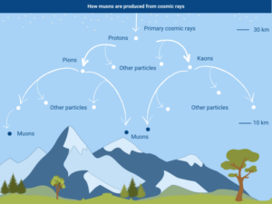
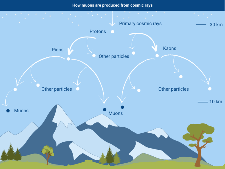
Formation of muons from particle showers (Vlasov, 2023).

Muons are natural subatomic particles that are created from cosmic rays interacting with atoms in the atmosphere. With their mass around 207 times that of electrons, muons are capable of penetrating solid materials and water (Gururaj 2023). This unique property of muons has allowed for their use in mapping the interiors of hard-to-access places such as volcanoes, tropical storm cells, and even Egyptian pyramids (Morishima, 2017). Professor Tanaka’s team has now focused on improving the currently limited GPS system with a wireless muon detection system capable of navigation in places where radio waves used in GPS can not reach. This makes it an ideal technology for underground and underwater navigation, natural disaster relief, exploration of caves in planets, and much more. 

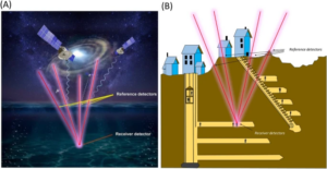
While the initial principle behind MuWNS involves the precise measurement of the timing and direction of cosmic-ray-generated muons through reference detectors, Professor Tanaka’s team had issues with the synchronization of time between the reference and receiver detectors (Tanaka, 2022). This precise time synchronization issue was displayed in their 2022 MuWNS prototype that had a navigation accuracy between 2-14 m, which Professor Tanaka claims is “far from the level required for the practical indoor navigation applications.” In a more recent article published in September 2023, Professor Tanaka has shifted his focus from using the timing of muons to measuring the directional vectors of incoming muons. Thus, instead of using the time of muon travel between the reference and receiver detectors for navigation, the next generation vector muPS (muometric positioning system) uses the angles of incoming muons through the reference and receiver detectors to locate the detector’s positioning. In essence, matching the angles of muons entering the two detectors confirms the same muon event. By identifying the same muon event, the angle and path of the muon is then used to determine the position of the receiver detector without relying on timing mechanisms. This approach minimizes the effects of time synchronization resulting in what he predicts as centimeter-level accuracy (Tanaka 2023). This new development has been greeted with excitement, earning Professor Tanaka’s team a spot in Time Magazine’s “The Best Inventions Of 2023” (Stokel-Walker 2023).

This image is from Professor Tanaka’s article on wireless muometric navigation systems. Image A depicts underwater navigation with floating reference detectors and muons marked as red lines. Image B depicts underground navigation using surface reference detectors to control the receiver. (Tanaka, 2022).

After being intrigued by Professor Tanaka’s work published in Nature (Tanaka 2023), I reached out to him asking a few questions for this article. The first question I asked was about the presence of muons and whether muon tomography could work on other celestial bodies. His response highlighted that muons are in fact generated in dust deposits on top of the surface of the Moon and Mars. Specifically, Professor Tanaka discussed how muons could be used to explore caves within the Moon. This would involve deploying a muPS navigating robot that uses muons generated in the regolith for navigation underground. This could allow us to explore hard to examine places on other planets without the physical presence of human exploration.

The second question involves the application of muPS within cell phones. Tanaka explains that our phones currently have a GPS receiver inside of them, allowing us to track their location when they are lost. However, if the cellphone is lost in an elevator, basement, cave, or room that has limited GPS signals, muPS could locate the phone instead. With 6.92 billion smartphone users worldwide, this application could be useful in natural disasters where individuals may be trapped under rubble and GPS signals cannot locate their phones (Zippia 2023). 

Finally, I asked Professor Tanaka what made him excited about muPS. He responded by discussing the current limitations with our present indoor/underground navigation systems and how they all rely on laser, sound, or radio waves to guide them through obstacles. This method he claims is not technically navigation because it does not provide coordinate information and thus is un-programmable. Tanaka states that “muPS is [the] only technique that provides the coordinate information besides GPS” and it can be used in locations where GPS is unavailable. 

In future technology, muon-based positioning systems may provide the opportunity to open new navigational and observational possibilities, propelling us into a world of new discoveries and exploration on Earth and beyond. 


Work Cited

  1. Gururaj, T. (2023, June 16). World’s first cosmic-ray GPS can detect underground movement. Interesting Engineering. https://interestingengineering.com/innovation/cosmic-ray-gps-underground-movement-disaster-management-muons 
  2. Howell, E. (2018, May 11). What are cosmic rays?. Space.com. https://www.space.com/32644-cosmic-rays.html 
  3. Morishima, K., Kuno, M., Nishio, A. et al. (2017). Discovery of a big void in Khufu’s Pyramid by observation of cosmic-ray muons. Nature 552, 386–390.. https://doi.org/10.1038/nature24647
  4. Stokel-Walker, C. (2023, October 24). Muon Positioning System: The 200 best inventions of 2023. Time. https://time.com/collection/best-inventions-2023/6326412/muon-positioning-system/ 
  5. Tanaka, H.K.M. Wireless muometric navigation system. Sci Rep 12, 10114 (2022). https://doi.org/10.1038/s41598-022-13280-4
  6. Tanaka, H.K.M. Muometric positioning system (muPS) utilizing direction vectors of cosmic-ray muons for wireless indoor navigation at a centimeter-level accuracy. Sci Rep 13, 15272 (2023). https://doi.org/10.1038/s41598-023-41910-y
  7. Vlasov, A. (2023, April 14). Muon Imaging: How Cosmic Rays help us see inside pyramids and volcanoes. IAEA. https://www.iaea.org/newscenter/news/muon-imaging-how-cosmic-rays-help-us-see-inside-pyramids-and-volcanoes 
  8. Zippia. 20 Vital Smartphone Usage Statistics [2023]: Facts, Data, and Trends On Mobile Use In The U.S. Zippia.com. Apr. 3, 2023, https://www.zippia.com/advice/smartphone-usage-statistics/

Filed Under: Computer Science and Tech, Math and Physics

Primary Sidebar

CATEGORY CLOUD

Biology Chemistry and Biochemistry Computer Science and Tech Environmental Science and EOS Honors Projects Math and Physics Psychology and Neuroscience Science

RECENT POSTS

  • Floating Systems: Jellyfish and Evolving Nervous Systems May 22, 2025
  • Biological ChatGPT: Rewriting Life With Evo 2 May 4, 2025
  • Unsupervised Thematic Clustering for Genre Classification in Literary Texts May 4, 2025

FOLLOW US

  • Facebook
  • Twitter

Footer

TAGS

AI AI ethics Alzheimer's Disease antibiotics artificial intelligence bacteria Bathymetry Beavers Biology brain Cancer Biology Cell Biology Chemistry and Biochemistry Chlorofluorocarbons climate change Computer Science and Tech CRISPR Cytoskeleton Depression dreams epigenetics Ethics Genes honors Luis Vidali Marine Biology Marine Mammals Marine noise Medicine memory Montreal Protocol Moss neurobiology neuroscience Nutrients Ozone hole Plants Psychology and Neuroscience REM seabirds sleep student superintelligence Technology therapy

Copyright © 2025 · students.bowdoin.edu